For public safety, situational awareness is everything. More information about the surrounding environment helps first responders make better decisions to keep personnel and the public safe.
Location-Based Services, or “LBS,” use geographic and location data to provide information to users, such as the longitude, latitude and/or altitude information of personnel, vehicles or assets. LBS technologies provide the ability to visualize and act on this data in near real time with mapping tools or other capabilities, such as geo-fencing. Public safety entities can locate a responder, not just a vehicle, regardless of where the responder is, and without any verbal input.
In today’s environment, public safety entities track responders’ location using a wide assortment of options, all with varying degrees of accuracy, effectiveness, and automation, from handwritten maps to smartphone applications. Using location-based services to locate individual first responders can be absolutely critical in terms of personnel safety and accountability, improved response times, and enhanced operational effectiveness.
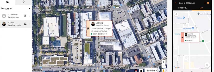
Z-Axis for FirstNet offers vertical location mapping capabilities, allowing a new level of indoor spatial awareness not available using traditional GPS-based location methods. Intrepid Networks’ Response for FirstNet, a situational awareness platform, is the first to bring Z-Axis capability to market via FirstNet.
The following demonstration of Z-Axis for FirstNet was recorded live in downtown Chicago using Response for FirstNet application. Watch to see the information displayed on mobile devices and desktop displays, as well as streaming video from the person being tracked.
Location based services are vital for all public safety disciplines, communities of any size, and the many unique operating environments where public safety responds, and they are a priority within the First Responder Network Authority’s Situational Awareness Roadmap domain. Learn more about how we plan to drive technology advancements at FirstNet.gov/Roadmap.
This video is a demonstration of Z-axis tracking capabilities. It does not constitute an endorsement by the FirstNet Authority of any product, service, organization, company, information provider, or content.


